Comment

Transmission Gully Road changes traffic flows north from Wellington – SH1 vs SH2 (& SH58)

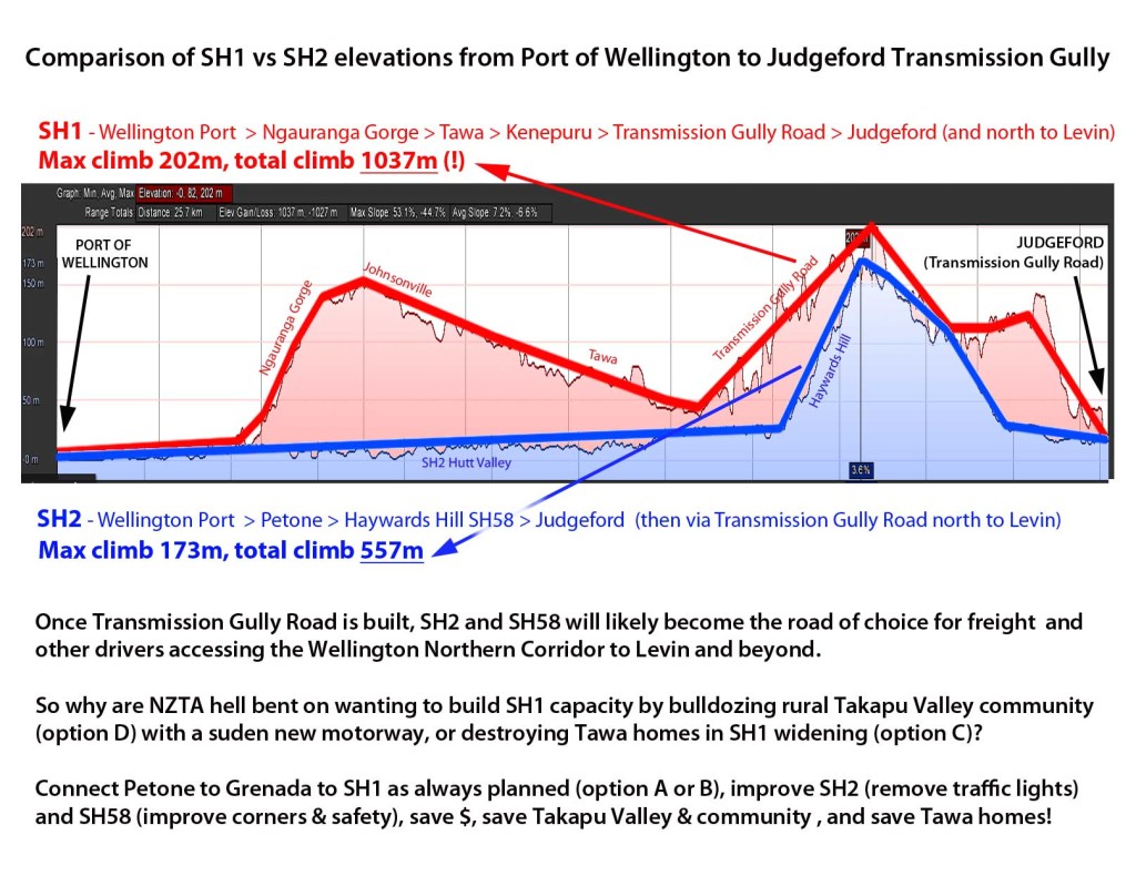
We were wondering what Transmission Gully Road would do to Wellington traffic flows once completed?  Transmission Gully will shift the main Wellington northern corridor east, bissecting SH58 at Judgeford.  What would this mean if you were a truck heading north from Wellington? Save for a few traffic lights on SH2, your route is clearly much better via SH2 and SH58 for fuel economy and wear and tear (see blue line below).  So why are NZTA saying they need to invest $50-150m on extra capacity between Tawa and Porirua (SH1 widening or bulldozing rural Takapu Valley to make a ridiculous short parallel motorway), when for much less money they could remove traffic lights and fix a few bad corners on SH58?

Transmission Gully changes to traffic flows SH1 vs SH2 north from Wellington

Transmission Gully changes to traffic flows SH1 vs SH2 north from Wellington

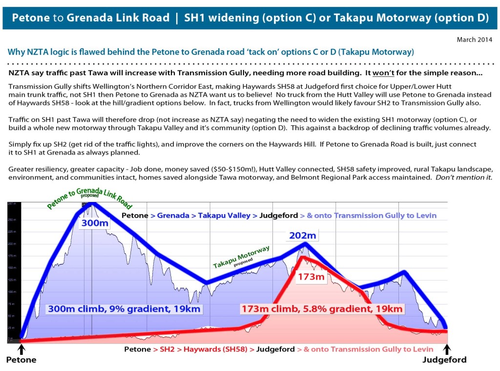
These sudden proposals (options C and D) have arrived without Council knowledge and have totally circumvented the regional and district planning process.  It’s clear to see that they’re being rushed through with haste by NZTA with no regard to wider regional needs.  We say build Transmission Gully, and build Petone to Grenada Road if necessary, but wait to see what will happen before destroying communities and a whole rural valley.

NZTA tell us traffic volumes are going to miraculously skyrocket after Transmission Gully sending much more traffic past Tawa.  We find this incredibly hard to imagine given traffic volumes have been dropping in Wellington, and when this elevation infographic diagram above suggests that Hutt Traffic (and possibly much Wellington Traffic) will prefer SH2/SH58 (over SH1 past Tawa) to Levin and beyond, further reducing flows.

Overall, this adhoc major infrastructure building by NZTA in road project silos is not serving the Wellington Region well.  All these roads need to be put through a proper established strategic planning framework.

Intro to the Options

A quick rundown for viewers just joining us…

Okay, so what is the deal with this road?

Here’s the current road layout in Wellington. The “Project Area” we’re talking about here is the big wedge from basically where SH1 and SH2 split in the south, up to SH58 in the north.
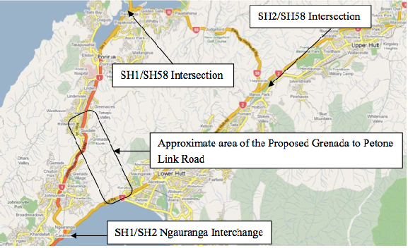
PFR Project Area

Figure 4.1 from the SKM Project Feasibility Report

NZTA and various local bodies have been talking about some version of this link road since at least 1991, and there are two primary problems they want the road to solve.

Problem 1: CONNECTIVITY

You’ve got SH1 in the west, and SH2 going up the Hutt, and there’re currently only two ways to get between one and the other:

  1. go down the Gorge at Ngauranga, and back up SH2 along the coast
  2. noodle around the Porirua inlets on SH58 and go down Haywards Hill

“Resilience” has become the buzzword du jour, and this is essentially an aspect of connectivity. If that bit of SH2 along the harbour gets eaten by the sea, or the hill falls on it, it’d be nice to not have to go all the way up to SH58 at Pauatahanui to get back to Petone.

Problem 2: CONGESTION

Ngauranga Gorge – it’s a big steep hill, with a couple of sharpish bends. In the AM peak, traffic backs up from here to Tawa. Out-of-peak, though, traffic flows are fine.

SH2 Aotea along the harbour to Petone – everything slows to a crawl at the PM peak, backing up all the way into town.

Really, this is just “connectivity” again – if we had another way to get from A to B, there’d theoretically be fewer cars using the congested routes.

So what’s the (current) plan?
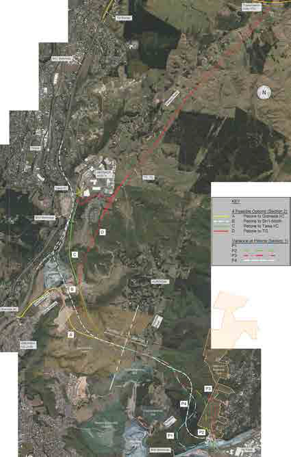
Options from the Scoping Doc

Figure 12.8: Options Selected for Development, from the Scoping Report


Clear as mud?

What the Petone to Grenada proposal does, basically, is builds a second gorge road, so in addition to SH1 coming up Ngauranga, there will be a new, slightly steeper gorge road coming up Korokoro from Petone and joining SH1 at… well there’s where it gets tricky.

They came up with four options for the Northern end.


Option A – Petone to Grenada
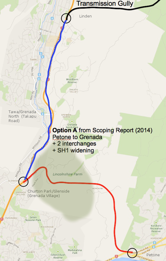
Option A map

Option A: Petone to Grenada

Option A goes through Lincolnshire Farm to the Mark Avenue roundabout, and then runs along the existing Grenada Drive to the existing Grenada Interchange (Churton Park/Glenside) with SH1. Grenada Drive, the SH1 interchange, and the Mark Avenue roundabout would all be upgraded. This is basically the way that everyone has been expecting the link road to connect since the first detailed study in 1991. It’s written into the Lincolnshire Farm Structure Plan, and the local property lines have been drawn to keep out of the way.

Option A has the fewest number of interchanges, and according to the Scoping Report, does the best job of making traffic flow smoother and faster. It also has the least number of slip-vulnerable road cuts, and does the least amount of damage to the landscape.

This is one of the two “rejected” options.

NZTA says that if they go with this option, they would also need to widen SH1 from the Grenada interchange north to Transmission Gully. More on that later.


Option B – Petone to Not-Quite-Tawa
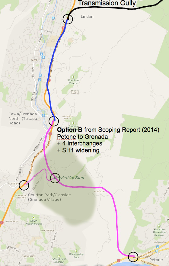
Option B map

Option B: Petone to Not-Quite-Tawa

Option B connects to SH1 at a new interchange between the existing Tawa and Churton Park interchanges. The bit from the Mark Ave roundabout down Grenada drive is used as a link road (as-is, where-is apparently). The new interchange with SH1 south of Tawa is one-way pointing north. Meaning,

  • If you’re coming from south of Churton Park, you get onto the P2G from Churton Park via the Mark Avenue link road.
  • If you’re coming from north of Tawa, you get on at the new south-of-Tawa interchange.
  • If you’re coming from Tawa, Grenada North, or Takapu Valley, you’re stuffed, because they’ve also taken the southbound ramps off the existing Tawa interchange. To get to Wellington or Petone, you’ll need to take Middleton Road to Churton Park and best of luck from there.

Not surprisingly, this one has the worst traffic flows. Also, it’s more expensive, because they routed it through the old Northern Landfill.

This is one of the two rejected options.

NZTA says that they would also need to widen SH1 from the Tawa interchange north to Transmission Gully. More on that later.


Option C – Petone to Tawa
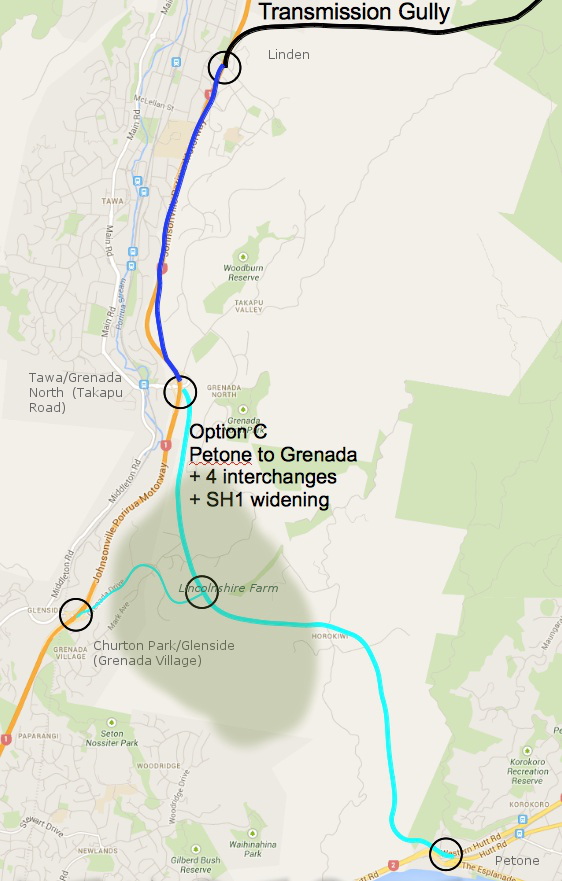
Option C map

Option C: Petone to Tawa

Option C is much like Option B, except that they manage to miss the Northern Landfill, and instead they go through a bunch of homes that have just started construction in Grenada North. They then swoop up to connect to SH1 at the existing Tawa/Grenada North interchange. There’s about 2km where the two motorways run parallel to each other, something like 50 meters apart.

Tawa gets this:
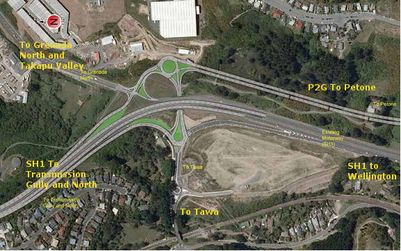
Proposed Tawa Interchange

Figure 16-4: Modified Interchange at Tawa

You’ve got traffic from two high-speed motorways joining each other through a series of roundabouts, and if you’re coming from Tawa, Grenada North, or Takapu Valley, you get to try and leap into the middle of that. Be sure to have your life insurance up to date. And if you’re one of those that currently walks or cycles between the train station and points east… well, don’t.

From a resilience perspective, this option has some moderate road cuts that could be vulnerable to slips. For more day-to-day issues, in theory you could use the bit from Tawa up through Lincolnshire and back down to Churton Park to get around a crash on SH1, if you didn’t want to use Middleton Road (or couldn’t get to Middleton road across the clogged roundabouts.)

This is one of the two “preferred” options.

NZTA says that Option C will also require widening SH1 from the P2G interchange north to Transmission Gully. More on that later.


Option D – Petone to Transmission Gully
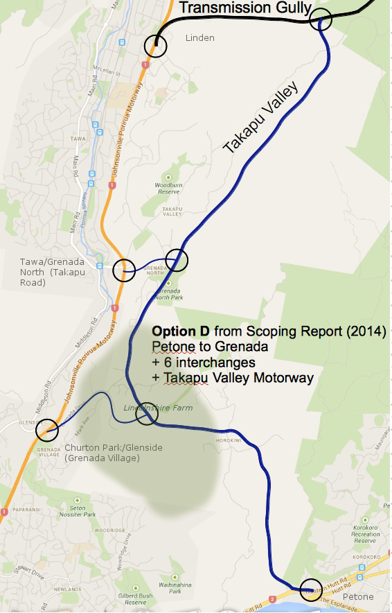
Option D map

Option D: Petone to Transmission Gully

Option D doesn’t bother connecting to SH1 at all, instead opting to re-package the old Transmission Gully route (scroll down) up Takapu Valley.

So if you are coming from Petone on the P2G, and you want to go to Tawa or Porirua, you have to get off the P2G and noodle through two or three roundabouts to do it. If you stay on the P2G, you are shunted directly onto Transmission Gully northbound (no option to go east to Linden).

Tawa still gets that exciting new interchange, but instead of running parallel to SH1 to the south, there’s a link road that curves up under a new Jamaica Drive flyover and connects to the P2G (which now runs behind Grenada North) at yet another interchange.
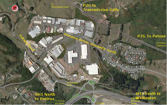
Tawa Interchange Option D

Figure 17-5: New Grade Separated Interchange at Tawa

Option D wipes out the Grenada North sports fields, and bisects all of the properties on the eastern side of Takapu Valley – including two that have been farmed by the same families since the 1800’s – taking out a few homes on the way through.

There are some diabolical gullies to cross at the bottom of Takapu Valley (read: EQ risk), and the proposed alignment runs between the Wellington gas main, the Wellington water main, and several sets of high voltage power pylons on the western side, and the active but unstudied Takapu spur of the Moonshine fault on the eastern side.

At the north end, where all of the sets of power lines converge on the Takapu Road sub-station, they need to tuck in an interchange with Transmission Gully while still theoretically allowing access to Belmont Regional Park as well as the substation itself. The terrain gets excitingly gorge-y up that end as well, and they’re going to need both flyovers and an underpass – more EQ risk.
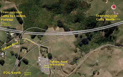
Transmission Gully Interchange

Figure 17-6: North Facing Ramps at Transmission Gully

Similar to Option C, instead of Middleton Road you could theoretically use the piece of the P2G between Tawa and Churton Park to bypass a crash on that short bit of SH1. You couldn’t use the bit through Takapu Valley, though, because the ramps at the north end are one-way – you can’t get onto the Takapu Valley stretch of P2G from Linden, and you can’t turn toward Linden from the Takapu Highway – in either case you can only continue along TG to Waitangirua and Whitby.

This is one of NZTA’s two preferred options.

NZTA says that Option D would take 7500 vehicles per day off of SH1, and that’s enough that if they did this option, they wouldn’t need to widen SH1.

The next post will discuss widening SH1, and the traffic figures that NZTA is using to justify this work. SPOILER: They don’t add up.


Links and notes:

The Petone to Grenada Project  on the NZTA website.

The “Scoping Report” is NZTA’s Petone to Grenada Scoping Report 2014, available on the P2G’s Publications page.

The “PFR” is the Ngauranga Triangle Strategy Study Petone to Grenada Link Road Project Feasibility Report, 2010, by Sinclair Knight Merz (not online).

Map underlays for the four options are from Google maps.  Alignments are approximate — refer to the Scoping Document for more precise alignments.

Petone to Grenada Link Road ‘Takapu Motorway tack on’ has big recreation implications for Belmont Regional Park

NZTA plans for a new motorway through Takapu Valley (option D), by tacking it onto the Petone to Grenada Link Road, has major implications for Wellington’s outdoor recreation users.

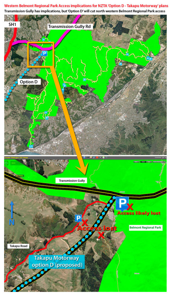
The proposed ‘Takapu Motorway – option D’ will effectively cut off the key access points to western Belmont Regional Park, leaving only southern and eastern points.  These access points are important for mountain bikers, trampers, walkers and horse riders, with the carpark often overflowing on sunny weekends.

Belmont Regional Park access issues by proposed NZTA Takapu Motorway (option D)

Belmont Regional Park access issues by proposed NZTA Takapu Motorway (option D)

We know the Greater Wellington Region is very proud of this park, so loosing these access points is of great concern.  The whole plan has arrived suddenly, doesn’t exist in any district planning, is being driven with haste, will have little consultation, compared to Transmission Gully and the Petone to Grenada Roads which have had decades of consultation.  This is madness.

“Ōhariu MP Peter Dunne is calling on NZTA to drop altogether proposals for a link road between the Transmission Gully Highway and the planned Petone to Grenada road “until it gets its act together.” 

We think the impacts on recreation in the Wellington Region also warrant a major rethink about this sudden adhoc last minute tack onto the Petone to Grenada Link Road.

Endemic bullying culture in NZTA?

We’re fast developing an appreciation for how NZTA work.  They’re running roughshod through communities and have unleashed a strategy to divide and conquer locals via Option C (widening existing SH1 motorway), or Option D (Takapu Motorway), and giving people 6 weeks consultation to fight major plans, that have no public planning, from a cold start.  It’s unfair, unjust and unethical!  Peter Dunne MP has alluded to this last night.

So it’s not surprising when we find letters like this NZTA letter bullying the Wellington City Council into submission:   http://savethebasin.files.wordpress.com/2012/12/nzta_wcc_letter_121219.pdf

Is it time for Kiwis to take a harder look at our biggest Government agency’s behaviour and take the Chief Executive to task?

You’d think being chastised twice by a Cabinet Minister would be enough to halt the NZTA’s outrageous plans to bulldoze a 4 lane Motorway through Takapu Valley without due process, consultation or planning.

We’re slowly uncovering considerable incompetence by NZTA (such as watching WCC grant consent for a whole subdivision soon to be bulldozed – that could cost WCC ratepayers dearly I’d think), and an intrinsic culture of lies and deceit to the public and landowners.  We’ll be documenting this more, one action with possible criminal implications.  Not to mention the unethical and immoral strategy of playing neighbours and communities off against each other to do their work.  Questions need to be asked of this Government Department and it’s Chief Executive that condones such behaviour, paid for by the tax payer.  Peter Dunne is right to be concerned by this behaviour.

“Time to Drop the Link Road Proposal”

Ōhariu MP Peter Dunne is calling on NZTA to drop altogether proposals for a link road between the Transmission Gully Highway and the planned Petone to Grenada road “until it gets its act together.”

Mr Dunne says NZTA’s handling of the link road plan which emerged only three weeks ago has been a “public relations and planning disaster from the outset.”

“I think the plan is now doomed because of its own incompetence, and the sooner it is dropped altogether, the better.

“First off, was the announcement that the preferred option was to slice a link road through Takapu Valley, understandably angering the 80 odd residents who live there, and who had no idea that was being considered.

“Then, NZTA refused to front angry residents at a site meeting, saying it was not ready to talk to them yet, and would prefer to do so on a one-on-one basis anyway.

“Next was the announcement that if they could not proceed with the Takapu Valley option, NZTA would callously play communities off against each other by widening State Highway One by Tawa instead, affecting about 40 properties.

“That brinkmanship is simply disgraceful.

“Now comes this week’s news that people buying sections in a new subdivision at the top of Grenada Village find the proposed road cuts right through the land they are in the process of buying.

“NZTA was even not aware of that until I raised it with them earlier this week.

“These are inept blunderbuss tactics of the worst type – despite its assurances to me personally and in public, NZTA seems to have no comprehension of, or concern about the impact of its cavalier announcements on local resident who stand to be seriously adversely affected.

“In the circumstances, NZTA’s only credible option is to can the plan now, go back to its drawing board, and work with the local community, the Tawa Community Board, and the Wellington City Council on the best way forward,” Mr Dunne says.

Peter Dunne stands up on the appalling behaviour of NZTA on Twitter   | 1 Feb 2014

@nzta_news cowardly on Takapu Valley Road – you cannot ride roughshod over people & then refuse to front, so just drop this mad idea now”

https://twitter.com/PeterDunneMP/status/429484656065380353

Dunne Seeking Answers on Takapu Valley Roading Plan

Ōhariu MP Peter Dunne is seeking a full briefing from NZTA on its roading plans that are likely have an impact on Takapu Valley residents.

Mr Dunne says he first became aware of the specific proposals yesterday, and shares the concern being expressed by Takapu valley residents.

“Proposals like this which come like a bolt from the blue are understandably very disruptive of people’s lives and need to be handled with sensitivity, something government agencies are often not very good at”.

“However, it is not entirely clear how firm the plans are, which is why I want a full and urgent briefing from NZTA”.

“In particular, I want to know:

  • The actual status of the proposals currently being reported;
  • How, if at all, this proposal is linked to the development of the Transmission Gully highway;
  • The current status of the Petone to Grenada link road proposals;
  • The time frame for and projected cost of the construction of any link road through Takapu Valley;
  • The process and time frames for reaching any decision on the proposal;
  •  What alternatives and other options might be considered;
  • The rights of affected property owners”, he says.

Roads of National Significance – Greenfields to Motorway by stealth – Takapu Motorway

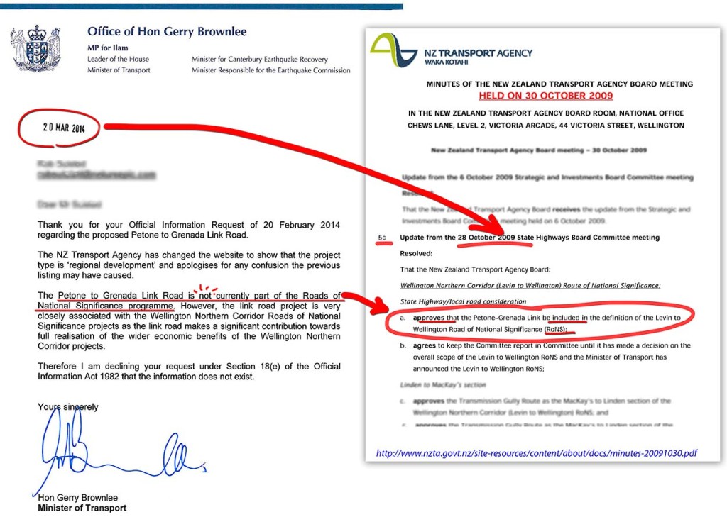
NZTA quietly decided the Petone to Grenada Link Road would become a Road of National Signficance (RoNS).  The minute note below shows.

This is very signficant.  It means that the road does not have to meet the same cost benefit analysis of other roads, and also gets fast tracked through planning and consent processes and environmental safeguards.

NZTA have suddenly tacked a ‘Takapu Motorway’ (Option D) onto the Petone to Grenada link Road (P2G).  The P2G has been discussed since 1975. In contrast the Takapu Valley Motorway was dropped on residents, farmers and landowners a mere 3 weeks ago out of thin air!  It exists in no planning or consultation documents publically available!  NZTA are giving 6 weeks consultation to fight a motorway from a cold start.  Is this how NZ works these days?

By virtue of NZTA quietly adding P2G to the RoNS (somehow they’re saying the P2G road is in the Wellington Northern Corridor [Wgtn Airport to Levin]), and then suddenly tacking a while new ‘blue sky’ Takapu Motorway on at the last minute, you get from green fields to 4 lane motorway with no District Plan, Strategic Traffic Planning, fair public process, or regard for communities.

Amazingly brazzen feat of total disregard for public process and democracy by New Zealand’s largest Government Ministry

5c
Update from the 28 October 2009 State Highways Board Committee meeting
Resolved:That the New Zealand Transport Agency Board:
Wellington Northern Corridor (Levin to Wellington) Route of National Significance: State Highway/local road considerationa.APPROVES that the Petone–Grenada Link be included in the definition of the Levin toWellington Road of National Significance (RoNS);
b.AGREES to keep the Committee report in Committee until it has made a decision on the overall scope of the Levin to Wellington RoNS and the Minister of Transport has announced the Levin to Wellington RoNS
As I write this, the Petone to Grenada Road website says P2G IS a RoNS project and outlines its tenious link, while the RoNS website map show P2G ISN’T a RoNS?  I expect this to change or the links to die, as we’re fast discovering that NZTA are good at manipulating what they share with the public online.

Welcome!

Hi folks

It’s 30 January, 2014, and the residents of Takapu Valley have just found out that the New Zealand Transport Agency wants to put a highway through the valley.  As you can imagine, we’re all a bit worked up.  :^)  We’ve set up this website to help us communicate with each other, and with the greater Wellington community and beyond.

Takapu Valley has many remnants – biodiversity remnants (we have no trout in the valley, but abundant native fish), heritage remnants (some of the land is still in original ownership from Wellington’s early days), and social remnants (we’re one of the few close-knit rural communities left in Wellington).  We think it’s worth protecting from a proposed road that has no clear stated objectives, and is a last minute tack on to the long standing Petone to Grenada Road.