Takapu Valley
by Vivienne Townsend
Maori History
Takapu is the name given by Maori to the stream and valley up which Takapu Road now runs. Maori crossed it as part of the track to Porirua harbour to Te Whanganui a Tara (Port Nicholson). The track followed the Kenepuru Stream (now called Porirua Stream), up the southern slopes of the valley, to descend via the Korokoro Valley to Wellington. Ngati Toa are the mana whenua. (Murray, 2005).
First European Settlers
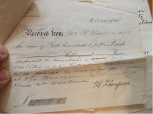
The valley was densely forested and proved difficult for the first land surveyors to negotiate, to the point where a member of the party recorded that after having spent some time struggling through the impenetrable undergrowth, “of Takapu we had seen enough”. (Carman, 1970) The valley was divided and sold off into lots in the 1840s. It was bought and cleared by the early European settlers, and has been farmed ever since. In 1866, 52 acres were sold to William Woodman and in 1888 his brother Oliver bought 50 acres. In 1890, 19 acres were sold to Edwin Hyde. Their farms are still worked by their descendants, Lloyd Hyde and Stuart Woodman. Woodman Drive is named after Stuart’s family. Stuart’s great-grandfather William was one of the first European settlers who travelled to New Zealand aboard the ship the Bolton, arriving at Port Nicholson in April, 1840. Both Lloyd and Stuart live in the cottages built by their ancestors. The original settlers’ cottage on the Woodman property was further back from the road than the one that is there now. The house Stuart lives in was built in about 1880. It shares a similar design to that of the Notts Farmhouse at Ivy Bank Farm, Middleton Road, Glenside. “There were 5 totara trees on the property”, he recalls, “And they were pit-sawn to make the frame for the house. When it was re-roofed in about 1980, we found hundreds of little nails that had been used for fixing the totara shingles. A lot of hard work went into building this house.” He adds, “I’ve still got the receipts for the purchase of a block of acres from Harry Thompson in March 1888.”
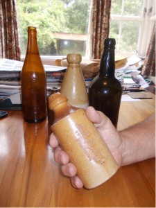
He continues, “We also turn up old artefacts from time to time – I’ve got an old spirits bottle and a couple of old ginger beer bottles made by George Dixon of Cuba Street.”

Stuart Woodman holding the ginger beer bottle from the site of the original cottage on the Woodman Farm.
The spirit bottle from the same site is on the right of the picture. The Tui bottle on the left and the larger ginger beer bottle in the centre at the back were found during maintenance work – digging culverts, etc., along the valley. The ginger beer bottles have the anchor stamp used by George Dixon’s company.
The Woodmans would use empty bottles like the Tui one in the photograph, to take tea up the hills when they were working. The bottles would have a bung or cork in them, and were hung over the horses’ necks for easy access. They would throw the bottles into the gullies when they were finished with them. Stuart found this bottle nestled in a native bush, where it had landed many years before. The softer landing in the branches saved it from breaking. Amongst the earliest settlers were George and Patrick Crowe, who were two of four brothers making a new life in New Zealand. They bought several acres in 1872 and made a route into the valley over the Horokiwi hills, clearing the bush and making a road as they went. In four years they had cleared enough land for Patrick’s wife and four children to join him. The only form of transport was by horseback and pack saddles. Mrs Crowe rode in by horse, holding her baby of six weeks. Due to the difficulties of travel she remained in the valley and did not see another white woman for a whole year. She eventually had 11 children of her own and acted as a local midwife. (Carman, 1970) As more land was cleared, a more suitable path was made along the valley floor.
Takapu Road School
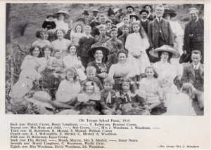
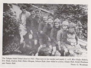
There used to be a school in the valley, which was situated near the road where the alpacas are bred today. It ran from 1897 to 1923. Prior to its opening, the Crowe children had to walk six kilometres (four miles) each way daily over the hills to schools in Porirua. The school was based in an old cottage on the Crowe’s property. It was fitted up by George Crowe with one large classroom, a teacher’s room and store. The roll varied as a number of children attended all year round, but others might attend for a term or two and then travel to other areas or miss school altogether, according to the needs of their families. It closed as other schools opened nearby and its roll began to fall. (Carman, 1970)

Lloyd Hyde’s father Eric can be seen in the second row from the back on the left, listed as being held by Mrs Hyde. In the front row can be seen Rita and Iris Woodman (Stuart’s aunts) and David Woodman (his father). Patrick Crowe can be seen in the back row.

Lloyd Hyde’s father Eric is second from the left, and his uncle Selwyn is fifth from the left. Selwyn was killed in action in Italy during the Second World War. John Woodman’s aunt Nolah is second from the right.
Woodburn Drive
Woodburn Drive, which runs off of Takapu Road was developed and named by Sir Ron Trotter, whose distinguished career included being the Director of the Reserve Bank of New Zealand and Air New Zealand and Chairman of Te Papa . His son still farms in the valley. (Murray, The Streets of Tawa, 2005)
Second World War Ammunition Store
During the Second World War American troops were stationed in Wellington. They had an ammunition depot and rifle range off Takapu Road. Many of the official records or references to the depot have been lost, but locals have described these things from memory. Aerial photos support their testimonies, confirming activity near the entrance to Granada North, where previously Horn’s pig farm was located. (Harland, 2007)
Today
It currently has 35 families living in it, who farm sheep, cows, pigs and alpacas. They also keep numerous other livestock such as hens and horses.
Bibliography
Carman, A. (1970). Tawa Flat and the Old Porirua Road. Wellington: Wright and Carman Ltd, Trentham. Harland, P. (2007). United States Marine Corps, 2nd Division, Ammunition Bunker, Takapu Road, Tawa Flat, Wellington, New Zealand, 1942-1945. Wellington: Tawa Historical Society Inc. Murray, B. (2005). The Streets of Tawa. Wellington: Tawa Historical Society Inc.

